
North Gozo hike: from Dwejra to the Salt Pans!
If you have made your way backpacking in Malta you should definitely visit the island of Gozo. This small island is perfect to explore all over on foot, I did a few stunning hikes on my days there so make sure to read my other Gozo hikes’ posts for all the things you need to know when hiking in Gozo!
NOTE: This blog contains affiliate links to pages selling products and/or services, I may get a small commission if you make a purchase through these links at no extra cost for you. There’s no sponsored content on this blog.
This hike will take you from the north-west side of the island to the top north and you could even extend it a little bit more for almost the entire north of Gozo. Hiking in Gozo was one of my favourite things to do in Malta by far!
Starting from the popular Dwejra Bay and hiking clockwise along the coast, you can expect to arrive to the the town of Malsarform in 3 hours after hiking over 14Km and passing on the way by the iconic Xwejni Salt Pans!
You could even keep hiking for an extra 3Km and make it to the touristy spot of Ramla Bay.
If hiking in winter, almost all over the hike you will be on your own! so, prepare to enjoy this incredible hike without the crowds!
How to get there
If you’re already in Gozo, you could walk to Dwejra depending on where your accommodation is located, otherwise there’s also a bus that arrives there. Check on google maps for the timings. The trip by bus from Victoria to Dwejra takes only 10 min.

If hiking late in the day, you could do this route on the opposite direction so you enjoy the sunset at Dwejra Bay.
Upon ending the hike at either Zebbug, Malsarform or Ramla Bay you will also find buses to go back to your hotel. Be prepared to wait for buses as they tend to pass once per hour.
What to take for this Gozo Hike
This is a relatively easy hike as it’s mostly flat, you will find just a few short climbs but nothing strenuous, just prepare for a +14Km hike with enough water and some snacks as you will not find any places to eat until you reach the town of Zebbug.

I always go hiking with my Camelback Reservoir which is super convenient for hydrating on the go. Keep in mind that tap water is not drinkable in Malta, please always aim to have a water bottle to refill to avoid using so much plastic.
The terrain for this Gozo hike is not technical, you could do it with sneakers although a good pair of hiking shoes is always better.
It’s good to download maps.me on your phone for offline maps, I like this one more than Google maps when going hiking around the world as in many cases it includes lots of trails that are not showing on Google.
Starting the North-West Gozo Hike
As the total walk should take you between 3-4 hours depending on your pace, you will also have enough time on your day to explore Dwejra and the Salt Pans.
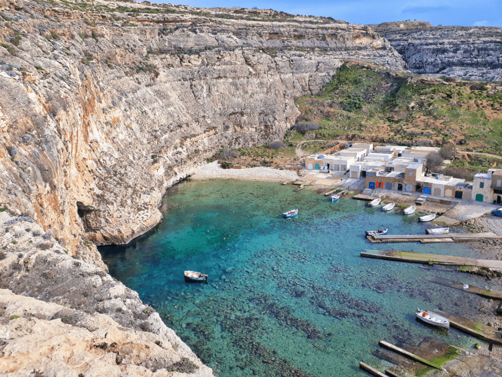
In Dwejra, you can take a walk from the bus stop to the bay, where you will find the Fungus Rock. Back into the “village” there’s also the oddity of the Inland Sea which is a small lagoon connected to the Mediterranean Sea via a natural arch carved by nature on the soft limestone.
You can take a small boat tour at the Inland Sea for just €4.
Dwejra is also one of the most famous spots in Malta for scuba diving.

Until recently, Dwejra also had one of the most iconic views of all Malta with the “Azure Window” which was a natural arch that had been featured among others in GOT, unfortunately an earthquake in 2017 made it collapse. Luckily, you will see more arches on this hike! 😉
Once you finish exploring the surroundings in Dwejra head towards the small church to find the trailhead which is located just on the back of the building.
The trailhead may be easy to miss at first, but if you look behind the church you will find some small steps carved on the limestone and a red dot painted on a rock.
The initial couple hundred meters are most of the climbing you will do on this hike and you will get a beautiful viewpoint of the Inland Sea!
If you look closer to the trail you will quickly see lots of fossils that have been embedded on the limestone for thousands of years.
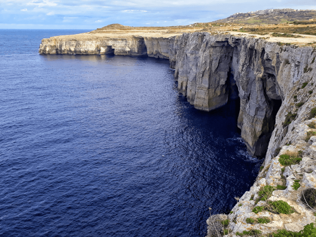
Once you finish the little climb you will start walking right next to the cliffs, I just love this sight, even after admiring them for a long time when hiking the south of Gozo!

Some 30 minutes after you left Dwejra you will leave the coastal trail as there’s an area of private land, there are also quite a few signs mentioning “Private Road, Do not Enter”.
I’m not 100% sure if these signs are legal of if there’s right of way. In any case, as when I was there I saw a few farmers in the distance I chose to stick to the rural road marked on maps.me to avoid any problems with the locals.

At one point the main road will also be cut by a “private road” sign which indicates a narrow unmaintained trail going down towards “Gharb Village”
Once out of the little trail, you will walk for about 2Km on a paved road until you find a sign that points towards “Tac-Cawla area mysterious Megaliths”, this sign plus another one warning you of taking a right turn because there’s a fireworks factory will take you on a trail to the left side of the road in the direction of the shore.

The area of the Megaliths is a bit curious, there are other sites like this one in Gozo and they’re believed to be mass graves of corsairs who attempted to ransack the island but were overcome by the local militias.
Once you pass the Megaliths there’s not much of a clear trail to follow, and that only means one thing: You make your own path!

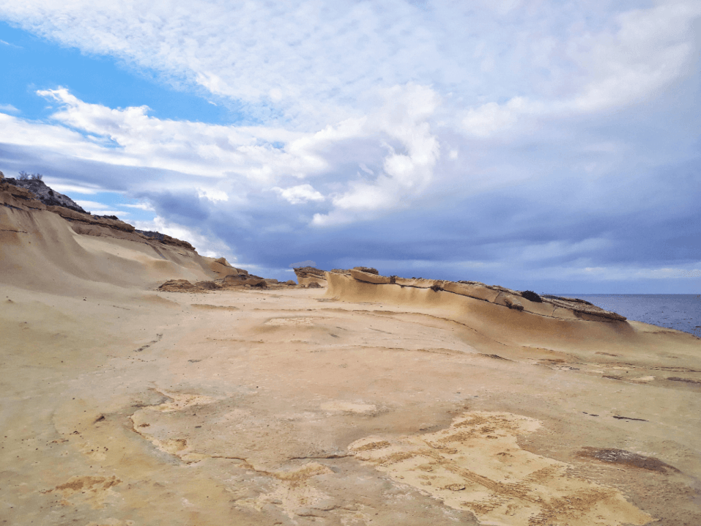
I went down close by the cliffs and started following the perimeter of the island again. Very quickly you will see how the terrain changes and the soft limestone that has been slowly and carefully carved by nature feels like walking on a different planet!
This was my favourite section of this Gozo Hike!

By now you don’t need to check your GPS anymore, just follow the coast and you will eventually arrive to different villages.
But before that there’s still plenty to see! such as the It-Tieqa natural archway which is just 1Km after the Megaliths. (It-Tieqa literally means window or aperture)

There are also plenty of other arches and little caves that can be seen on the cliffs which contrast with the neat “perfectly-cut” cliffs seen until this point on this Gozo Hike.
About 1Km walking along the coast after It-Tieqa you will see the town of Zebbug appear on the mountains, soon you will find yourself walking inland although still following the coast line as you will be entering the very narrow bay of Wied il-Ghasri.
Slowly you will see how at each step the gorge-like feature gets narrower until you find a small crossing to the other side, now following the trail back to the sea you will be able to go down a set of stairs to the small but beautiful pebbled beach of Wied il-Ghasri.

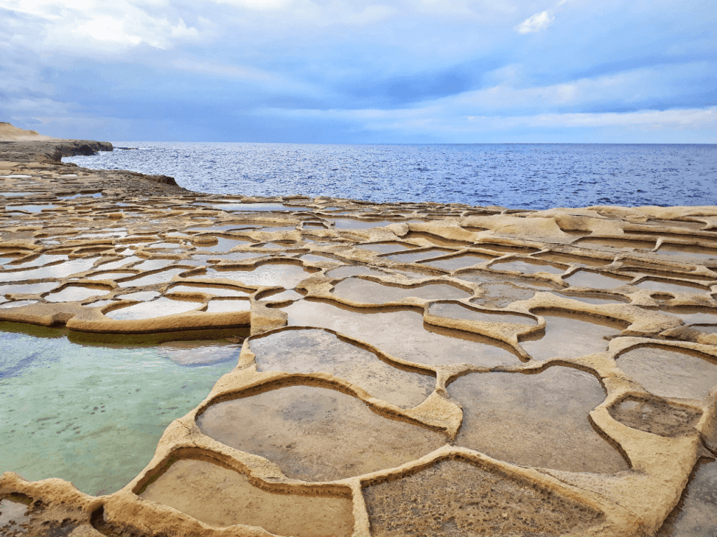
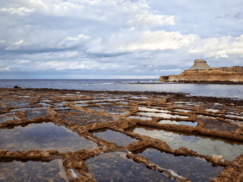
This Gozo Hike is just about to show another highlight of the island as very quickly you will find the first sights of salt pans and a short set of stairs going down towards the Billinghurst Sea Cave.
The eroded rock formations are also incredibly stunning, this was another of my favourite spots:
From the Sea Cave to Xwejni Bay you will have over 1.5Km of Salt Pans! there are some really cool spots to just admire the reflections the sky with the water in them. They vary in sizes and shapes, always surprising at every step you take!

Xwejni Bay is one of the few sites in the Maltese Islands where the sea eroded the limestone cliffs into relatively flat areas, the beach and bay are dominated by the last vestige of a chain of fortifications built in the early 18th century.
By now you can start of thinking of stopping your hike or continuing as the distances between villages are not long.
From the Salt Pans (at the bottom of the mountain where Zebbug is located) is only half an hour walk to Malsarform, and if you make it there you can walk an extra 3Km to Ramla Bay.
In all these locations you can take a bus back or walk inland to wherever you’re staying.
In case you decide to end your hike in Zebbug, I was recommended by a local friend to eat pizza at Francesco’s Bar, or at Murella which is in Marsalform. If it’s not time to eat and you happen to pass through the village of Nadur do not miss the opportunity to try the pizzas or local ftiras at Mekren’s Bakery! I still dream of them!
Hiking the North-West of Gozo
This Gozo hike was my one of my favourites of my time in this beautiful island, it’s totally worth it because of the varied landscapes that you will find. Technically is easy and you can adapt it in distance to suit your needs. What else can you demand of a hike!? 🙂

Check out the rest of my posts of my time backpacking in Malta and feel free to drop any comments or questions if you’re planning to go hiking in Gozo!


